Private

FS 3.507

Mountain influences on glacier atmosphere

Details

  • Full Title

    FS 3.507: Understanding terrain-driven influences on glacial change in mountain glacial regions
  • Scheduled

    TBA
  • Location

    TBA
  • Convener

  • Co-Conveners

  • Assigned to Synthesis Workshop

    ---
  • Thematic Focus

    No focus defined
  • Keywords

    glaciology, climate change, atmospheric modelling, observations, atmospheric processes

Description

Glacial changes are driven by interactions with the atmosphere. Therefore, understanding both the weather and climate of the atmosphere around glaciers and the physics of glacier-atmosphere interactions is critical for understanding the future prospects of the world’s glaciers, as well as interpreting the proxy record of past climate imprinted in ice cores. The atmosphere around glaciers is influenced not only by the regional circulation patterns, but also the topography surrounding the glacier which alters the atmospheric flow, particularly in mountain regions. These interactions also cause mountain regions to experience some of the most dramatic climate changes under global warming. The interactions of the topography with the regional circulation occurs on scales much smaller than the resolution of most atmospheric models, and high-quality observations of the atmosphere are not always available. These effects play a major role in controlling key energy and mass inputs to glaciers, introducing large uncertainties in studies using glacier models, and mean that the atmospheric processes influencing are often poorly understood.

Submitted Abstracts

ID: 3.10421

Glacier Landscape Investigation through Monitoring and Public Science (GLIMPS)

Tirthankar Ghosh
McCormack, Felicity; Ramsankaran, RAAJ; Mackintosh, Andrew

Abstract/Description

The landscapes of glaciated regions across the Himalayas and other alpine settings are undergoing rapid transformation due to accelerated global warming. These glaciers are vital components of the global water cycle and serve as critical buffers against water scarcity for millions of people. Glaciers have been monitored and studied for centuries, yet much of the photographic evidence of glacier changes remains poorly preserved or undocumented, especially in the Himalayas. By leveraging crowdsourced data and citizen science, combined with advancements in smartphone and camera technology, we can build extensive datasets capturing the evolution of multiple glaciers. This approach not only provides a cost-effective means of long-term monitoring but also engages communities in documenting the evolving glacial landscapes. Such datasets can support diverse scientific analyses, complementing satellite datasets with their unique vantage of the glacier fronts, including glacier area changes, glacial lake expansion, identifying calving events/or some other events such as glacier collapse, while serving as an invaluable record of the transformations occurring in these fragile ecosystems. Harnessing the collective effort of citizens, along with advances in photogrammetry and geospatial analysis, offers an opportunity to preserve the memory and science of these disappearing giants for future generations. We present a method to utilize the potential of crowdsourced data to build a library of glacier images and employ them to monitor various aspects of glacier change. This approach can provide an easy and cost-effective method of data gathering, which could be important for understanding the long-term impacts of climate change on critical water resources and mountain hazards and developing effective adaptation strategies for the affected communities.

ID: 3.10613

The Dynamic face of Batura Glacier- An Analysis of Glacier Area and Snout Movement in the Karakoram Region

Fakhra Muneeb
Ali, Syed; werner, Tim; Drysdale, Russel

Abstract/Description

Glacier fluctuations driven by climate change have exhibited increasing variability on a global scale, with diverse behaviour observed across different glacier systems. This variability in glacier responses is primarily influenced by the complex interplay of topography and localized climatic conditions, particularly in High Mountain Asia. This research focuses on Batura Glacier located in the Karakoram region. With the use of multi-temporal satellite imagery, we studied its area changes and the position changes of its snout from 1990 to 2022. Glacial boundary delineation was supported by high-resolution satellite data and field observations validated remote sensing information and enabled us to obtain localized glacier motion. Our analysis detected heterogeneous responses of Batura Glacier to climate change. The lateral translocation of the glacier snout between 1990 and 2022 is particularly marked. Shifts were noted from a left position in 1990 to a middle position in 2013 and further right by 2022. The field observations carried out in 2016 showed that the snout was covered by debris, although it had an average thickness of around 0.656 meters. The debris in the ablation zone of Batura Glacier is a mix of fine sand, coarse pebbles, and large boulders, with distinct differences on either bank of the glacier. On the left bank, granite boulders dominate, evidence of the glacier’s interaction with the underlying rock formations as it advanced and retreated over time. Field-based survey of the snout’s periphery was established in 2016 as a baseline for future comparisons. A follow-up in 2024 showed that the terminus had receded by approximately 120 meters over 8 years, reflecting a broader trend of glacier shrinkage across the Karakoram due to rising temperatures and changing precipitation patterns. Such field-based observations are crucial for understanding Batura Glacier’s dynamics and predicting its future behavior, which impacts local water resources. These results underscore the importance of combining satellite-based analyses with field data to understand glacier behavior in the context of regional climate dynamics. The Batura Glacier’s unique response highlights the necessity for localized studies to inform broader glaciological models in High Mountain Asia.

ID: 3.11628

A preliminary study of permanent snow cover in peruvian rock glaciers

Katy Damacia Medina Marcos
Loarte, Edwin; León, Hairo; Alejo-Mosquera, Miluska; Ubeda, José

Abstract/Description

Rock glaciers in Peru are key components of mountain permafrost, playing a fundamental role in terrain stability and water availability. However, their dynamics and the associated feeding processes, such as snow persistence, remain poorly understood. This study assesses the relationship between permanent snow cover and rock glaciers in the Peruvian Andes, focusing on its potential influence on the natural hazards characteristic of these regions.
More than 1,200 rock glaciers classified as active or transitional were analyzed using the Maximum Snow Extent (MSE) layer from the MOD10A2 MODIS product from 2002 to 2021. Permanent snow cover was defined as areas with a persistence equal to or greater than 80%. The results indicate that approximately 12% of the total rock glacier area (~75 km²) is covered by persistent snow, with a higher concentration in active rock glaciers (~68%). These areas of long-lasting snow cover are primarily located in the southern Peruvian Andes, where lower temperatures due to higher altitude favor ice preservation.
From a natural hazard perspective, permanent snow cover can play a dual role. On one hand, it contributes to maintaining the internal ice content of rock glaciers, regulating their thermal and structural stability. Besides, variations in snow persistence may influence permafrost degradation, affecting terrain stability and increasing the likelihood of triggering geomorphological processes such as landslides and ground subsidence on steep slopes.
These findings highlight the importance of snow cover in the evolution of rock glaciers and their dynamics in relation to natural hazards in the Peruvian Andes. The identification of areas with high snow persistence provides relevant information for managing these environments, particularly in the current context of climate change and its impact on mountain landscape stability.

ID: 3.12129

The influence of westerly moisture transport events on Kilimanjaro’s glaciers

Robert Peal
Collier, Emily

Abstract/Description

Rapidly retreating glaciers in Eastern Africa, such as at the summit of Kilimanjaro, are highly sensitive to moisture and precipitation variability. On sub-seasonal timescales, previous research has shown that precipitation variability in this region is closely related to the wind direction, with precipitation more probable on days where the wind blows anomalously from the west, advecting moisture from the Congo basin. However, the exact nature of the westerly circulation and the role played by interactions between regional moisture transport and the mountain topography in generating precipitation over the glaciers, is not well understood. Here, we use methods developed from studies of atmospheric rivers to objectively identify “westerly moisture transport events” (WMTEs), facilitating new insights into the seasonal distribution and importance of these westerlies, their impact on high elevation regions, and the role of both the Madden-Julian Oscillation and tropical cyclones in their development. Finally, we also use observations from the glacier at Kilimanjaro to investigate the role of WMTEs as drivers of sub-seasonal precipitation variability at high elevations near Kilimanjaro’s glaciers.

ID: 3.13074

Current status, trends and future challenges of the cryosphere in the Alps based on an example in the Hohe Tauern National Park

Clara Vydra

Abstract/Description

The European Alps are undergoing profound transformations due to climate change, with significant implications for their cryosphere, hydrology, and ecosystems. This master’s thesis project will provide a comprehensive review of how the German and Austrian Alps have changed across different elevation zones in response to climatic shifts, focusing on insights derived from remote sensing methodologies. By running this project in cooperation with the German Aerospace Center and the German Alpine Club results will directly influence decisions on the German Alpine recreational planning. By synthesizing existing scientific literature, the study examines key trends in glacier retreat, snow cover dynamics, vegetation shifts, and hydrological changes. Special attention is given to the role of satellite-based observations in quantifying these transformations at various spatial and temporal scales.
Based on this comprehensive theoretical review, a detailed case study will examine the water availability at Neue Prager Hütte, a high-alpine hut which has struggled with water access in late summer over the past years. Special interest lies on the seasonal and long-term variability of its primary water source – a connecting snowfield. Using remote sensing data combined with in-situ observations, the study will assess snow persistence and meltwater contribution. This localized analysis provides an example of how broader alpine climate trends translate into impacts on local water resources. Contributing to a deeper understanding of alpine climate change effects across elevation gradients this study highlights the critical role of remote sensing in monitoring and predicting future changes.

ID: 3.13674

Horcones Superior Glacier: Monitoring the Role of Debris Cover at the Top of the Americas

Juan Cruz Ghilardi Truffa
Ruiz, Lucas; Falaschi, Daniel; Lo Vecchio, Andres

Abstract/Description

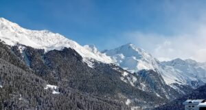
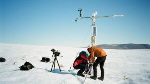
Glaciers in the Central Andes of Argentina are vital in the mountain hydrological system, contributing up to 60% of river flow during drought periods. This region contains 82% of the country’s debris-covered glaciers. Using remote sensing data, we observed a 21% increase in debris-covered areas over the past 40 years, with 62% of this growth occurring in the last decade. Despite their significance, the processes controlling mass loss and climate change responses by debris-covered glaciers are still poorly understood. To explore how debris cover affects surface ablation and ice dynamics, we recently installed monitoring equipment on the Horcones Superior Glacier (32° 4′ S, 70° 3′ W), located at the base of Aconcagua (6,962 m a.s.l.), the highest peak in the Southern and Western Hemispheres. Our setup includes an ablation stake network along the transition from debris-covered (0.5 m thick debris layer) to debris-free ice, temperature sensors to study heat transfer through the debris, and an Automatic Weather Station close to the glacier. Ground-penetrating radar (GPR) surveys were conducted to map debris layer thickness and ice thickness, and we used GNSS measurements to track surface velocity through boulders and stakes displacement. Additionally, we plan to conduct annual UAV surveys to monitor surface elevation and morphological changes in detail. We expect this monitoring approach to help us better understand the complex interactions between debris and ice and calibrate energy balance models. Our findings will improve our understanding of Andean debris-covered glaciers and their response to climate change.