Private

FS 3.121

Changing sediment dynamics in alpine fluvial systems as climate warms

Please log in to add items to your favorites.

Details

  • Full Title

    FS 3.121: Changing sediment dynamics in alpine fluvial systems as climate warms
  • Scheduled

    TBA
  • Location

    TBA
  • Co-Conveners

    ---

  • Assigned to Synthesis Workshop

    ---
  • Thematic Focus

    Cryo- & Hydrosphere, Hazards, Water Resources
  • Keywords

    Geomorphology, Sediment Transport, Hydrology, Cryosphere

Description

Climate warming has resulted in increasing sediment flux from mountainous regions around the world. Glacier retreat can destabilize slopes introducing sediment to fluvial systems below, potentially increasing sediment connectivity. Glacier lake outburst floods can rapidly mobilize large amounts of sediment. Changing frequency and volume of mass movements impacts sediment transfer to downstream systems. Increased freeze-thaw activity can cause bedrock to detach and become available for fluvial transport. Rising elevations of glacier melt mean that subglacial water can tap previously inaccessible sediment stores, increasing sediment export and changing sediment provenance. Despite the observed increases in sediment export, future sediment discharge will likely be limited by water availability and driven by extreme events. The evolving sediment fluxes in these regions impact downstream water quality and hydropower operations. Ecosystems remain sensitive to the stability of areas exposed by glacier retreat and sediment transported by rivers. This session aims to examine the impacts of climate warming on alpine fluvial systems. We welcome submissions that explore the changing sediment fluxes from these catchments and the processes responsible for supplying, transporting, or storing sediment as climate warms. This session will include field observations, remote sensing and modeling approaches, or a combination thereof. We are especially interested in research that makes forward-looking assessments of sediment export with climate warming and links these topics with glacier change, hydrology, hydropower operations, and biodiversity.

Submitted Abstracts

ID: 3.9177

25 Years of Lake Evolution and Sediment Dynamics in a Proglacial Environment: The Case of Sulzsee, Obersulzbach Valley, Austrian Alps

Jan-Christoph Otto
Dietel, Sabine; Hick, Roan; Heine, Erwin; Lang, Andreas

Abstract/Description

Glacier-fed lakes in proglacial environments allow insights into sediment dynamics and climate change adaptation of high mountains. These newly formed lakes influence the sediment cascade by collecting significant amounts of sediment from meltwater streams and paraglacial processes at the lake fringe. Proglacial lakes represent sediment traps that have a significant impact on sediment budgets and sediment availability in downstream fluvial systems, with implications for river ecology and bedload changes. Lake Sulzsee emerged 25 years ago from the retreating Obersulzbach glacier (Hohe Tauern, Austria) and has been intensively monitored with respect to lake evolution and sediment dynamics. Here, we document the phases of lake evolution associated with paraglacial adjustment of the lake shores and lake sedimentation patterns. We combined repeated bathymetric surveys and ground-penetrating radar for lake mapping and lake sediment quantification. Multitemporal surface change detection using high-resolution laser scanning data was used to quantify paraglacial sediment dynamics around the lake. Field and remote sensing mapping provided insight into geomorphological processes and ice-melt dynamics. We observed significant sedimentation within this 35 m deep lake mainly in a large delta and along the steep slopes towards the northern shore. After glacier retreat, sediment input is dominated by meltwater streams from the remaining glacier areas, surface erosion by debris and slush flows, and by shallow debris slides from the northern lake slopes. Individual large boulders on the lakebed represent the deposition of drop stones from the melting glacier. In recent years and decades after glacier retreat from the lake, bathymetry and open water volume changed significantly due to delayed melt of buried ice. We reconstruct the melting of ice preserved at the lakebed for over 20 years, leading to a delayed expansion of the lake area by more than 30% and a subsidence of the lakebed of up to 20 m. Onshore sediment dynamics along the northern slope show hotspots of erosion and significant deposition along the footwall and within the lake. On this slope, moraine deposits and till cover have partly been removed with bedrock now exposed indicating partial sediment depletion and an early end of the paraglacial adjustment in this part of the proglacial area.

ID: 3.9400

Bedload transport capacity evolution under climate change in Alpine catchments

Anne-Laure Argentin
Horton, Pascal; Gianini, Mattia; Schaefli, Bettina; Pitscheider, Felix; Repnik, Leona; Bizzi, Simone; Comiti, Francesco; Lane, Stuart

Abstract/Description

Bedload transport plays a critical role in shaping river systems, with significant implications for hydropower plant operations, riverine ecosystems, and the mitigation of natural hazards related to sediment transport and flooding. Despite its importance, the potential evolution of bedload transport capacity under future climate change in Alpine glacierized catchments remains poorly understood. We seek to address this gap by coupling a glacio-hydrological model to bedload transport capacity equations. This can inform how climate-driven changes in discharge are expected to affect bedload transport capacity in such catchments.

We rely on spatially interpolated meteorological datasets as model input for historical climate conditions and on corresponding climate change projections for an ensemble of future scenarios, both provided by MeteoSwiss. We use a semi-lumped hydrological model including an extended temperature-index melt model formulation (the melt model of Hock, 1999) to simulate glacier ice and snowmelt and mean discharge at the daily scale. We model the glacial area and volume changes over time using the delta-h method of Huss et al. (2010). To resolve sub-daily discharge variability, we developed a downscaling method based on the principle of maximal entropy. This method disaggregates mean daily discharge to daily flow duration curves at hourly time steps by relying on meteorological and hydrological variables. These flow duration curves are then integrated with bedload transport capacity formulations to estimate the maximum bedload volumes which could take place under conditions of unlimited sediment supply.

Our analysis was carried out in numerous gauged and ungauged high elevation glaciarized catchments across Switzerland, providing an extensive assessment of spatial variability in bedload transport capacity. This methodology is designed to be scalable to the entire Alpine region, offering a broader perspective on how climate change is modifying bedload transport rates and volumes.

ID: 3.9622

Extreme precipitation will trigger new and extreme sediment transport events?

Sara Savi
Comiti, Francesco; Zucca, Francesco

Abstract/Description

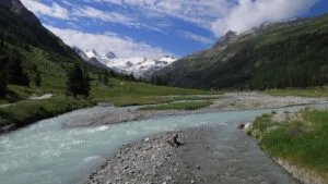
In the Eastern Italian Alps, the summer of 2023 has been particularly severe in terms of precipitation, with many intense thunderstorms concentrated in July and August. Several river basins within the Ortles-Cevedale massif were hit and have been affected by landslides, debris flows, and floods. Here, we describe the effects of a severe thunderstorm that hit the Ortles-Cevedale area on August 27th – 28th, 2023, reporting a few examples of the events registered in different locations. Data analysis of the precipitation event indicated a 48-hours cumulated rainfall ranging between 95 mm and 144 mm. Temperatures were always above zero, and the zero-degree isotherm ranged between 3’725 m a.s.l. and 3’330 m a.s.l. Most severe transport events were registered in the Sulden, Trafoi, and Forni valleys, and seem to have been directly influenced by the dynamics acting in the proglacial and periglacial areas of the corresponding glaciers. In the Trafoi and Sulden regions, the sediment-transport events were initiated as erosion on the moraines, either as deepening and widening of existing gullies, as well as moraine toe erosion by the proglacial stream. First estimates of the volumes mobilized during this rainfall event amounted to ca. 120’000 m3 (60’000 m3 in each catchment). In Trafoi, the sediment accumulated in the valley bottom damaged a famous touristic destination with an important historical and cultural significance. In the Sulden proglacial area, the sediment mobilized during this event completely outbalanced the system, for which previous estimates indicated a total mobilized volume of ca. 108.000 m3 for the 2005-2021 time period. Considering the morphological evolution of proglacial areas, and the potential amount of sediment that can be mobilized in these regions, the understanding of the sediment dynamics linked to extreme precipitation events will become crucial in a warming world, as intense rainstorms will likely become the primary triggers for severe and important sediment-transport events.

ID: 3.11021

Increased Sediment Availability and the Hazard Potential at Mountain River Confluences

Theo St. Pierre Ostrander
Holzner, Johannes; Mazzorana, Bruno; Andreoli, Andrea; Comiti, Francesco; Gems, Bernhard

Abstract/Description

The Alps are a natural hazard-prone region with increasing losses from torrential events involving fluvial sediment transport, debris floods, and debris flows. Torrential hazards typically involve large volumes of sediment transported from a source to a depositional area. The volume of sediment stored in the catchment correlates with the hazard potential; more supply equals higher sediment concentration resulting in an increased hazard from the torrent. Hazard and risk dynamics are intensified by anthropogenic climate change. Increased sediment availability and shifting flooding patterns threaten new infrastructure and challenge previously installed mitigation measures. Past mitigation measures, while effective, mainly address processes upstream of the depositional fan apex and do not consider processes occurring in the confluence.

Confluences are critical sites in all river networks and are particularly vulnerable to increased sediment supply, as the sediment loads and hydraulic geometries from each channel must be accommodated to avoid overbank flooding and sedimentation into adjacent settlements. Hydrodynamic and morphological processes at lowland river confluences have been extensively studied, but there is a gap in our knowledge of mountain river confluences. To better understand the effects of increased sediment supply from Alpine catchments, a large-scale physical model, which is a generic representation of confluences typically found in the Alps, was constructed in the hydraulic engineering laboratory at the University of Innsbruck. In addition, a coupled and validated sediment transport model was used to further simulate sediment transport and morphological patterns in the confluence zone. Results from both physical and numerical approaches indicated that as the sediment concentration increased, the depositional extents increased causing severe backwater effects in the main channel and extensive deposition in the torrent channel. However, an extremal equilibrium morphology developed as a function of flood magnitude and was characterized by specific geomorphic units that were optimized to enhance sediment transport through the confluence. These results challenge the previous conclusions regarding the hydro-morphodynamics of confluences. Therefore, the flooding and sedimentation hazards that occur at mountain river confluences pose a unique hazard, and the application of methods and knowledge based on lowland regions may severely underrepresent the hydro-morphodynamic interactions and the resulting hazard potential.

ID: 3.11422

Landscape geomorphological sensitivity: The paraglacial response of Alpine basins to rapid warming

Leona Repnik
Gianini, Mattia; Breillad, Arnaud; Giovanardi, Alessandro; Kjellqvist, Dennis; Comiti, Francesco; Argentin, Anne-Laure; Pitscheider, Felix; Lane, Stuart

Abstract/Description

Climate change is resulting in rapidly increasing temperatures in the European Alps, rising twice as fast compared to the global average. The resulting unprecedented glacier retreat is well studied, but little is known about the impact on sediment yield. Thus, the objective of this research is to understand the paraglacial response of Alpine basins to warming, especially in the context of peak water and peak sediment, through an inter-basin comparison.

DEMs (Digital Elevation Model) from aerial archival photogrammetry (1970s) and corresponding DoDs (DEMs of Difference) were created for multiple glaciated basins in southwestern Switzerland. These allowed for a basin-scale analysis of sediment erosion and deposition patterns. A comparison to records of sediment yield provided by hydropower companies was used to infer the drivers of these changing patterns and to better understand sediment export of these basins over the last decades.

The DoDs show very few localized sediment sources, with most hillslopes having remained stable over the studied time period. However, hydropower records indicate a rising trend in sediment export from these basins since the 1980s. This indicates that glaciers are the dominant suppliers of sediment in these glaciated basins.

These analyses suggest that during a period of rapid climate warming the sediment yield is dominated by glacial sediment supply and with only relatively small and localized supply from hillslopes, the latter representing the paraglacial supply. As glaciers become smaller and peak sediment is attained, we would expect the paraglacial component to gain importance, but remain inferior to the previous glacial erosion. The exact timing of peak sediment with respect to peak water will likely depend on a multitude of factors, including, but not limited to, glacier size, basin topography (slope), connectivity (including temporary sediment stores like overdeepenings) and the reduction of transport capacity following peak water. Understanding how sediment yield has been influenced by recent warming is crucial for predicting the future evolution of sediment export from alpine basins. This is especially relevant for anticipating ecological changes to fauna and flora, mitigating risks to human lives and infrastructure and managing hydropower installations.

ID: 3.11456

Exploring Bedload Fluxes in Alpine Rivers: Application of the D-CASCADE Model in the Sulden Catchment

Felix Pitscheider
Argentin, Anne-Laure; Doolaeghe, Diane; Gianini, Mattia; Repnik, Leona; Bizzi, Simone; Lane, Stuart N.; Comiti, Francesco

Abstract/Description

Sediment transport in Alpine rivers plays a crucial role in shaping river morphology, sustaining ecosystems, and influencing human activities such as hydropower management and hazard mitigation. However, predicting sediment fluxes in these environments remains challenging due to the complex interactions of hydrological processes, sediment availability, and connectivity within river networks. Additionally, the inherent difficulty of measuring transported volumes in the field further complicates efforts to quantify and model sediment dynamics. Climate change introduces another layer of complexity, as shifting precipitation patterns, glacier retreat, and the resulting transition of runoff regimes directly impact sediment transport processes.

In this study, we apply D-CASCADE, a network-scale sediment transport and connectivity model, to the Sulden/Solda catchment (Italian Alps) – a glaciated basin with a nivo-glacial hydrological regime and a well-documented history of sediment monitoring. The model offers the flexibility to analyse bedload transport dynamics across a range of temporal scales, from years to centuries and from daily to hourly timesteps, depending on available input data. By integrating hydrological data and sediment entrainment processes adapted to mountain streams into D-CASCADE, this research aims to assess the model’s capabilities in reconstructing past bedload fluxes while also providing a robust tool for simulating future scenarios.

Beyond quantifying bedload transport, this research explores the potential of D-CASCADE to enhance our understanding of sediment connectivity within Alpine catchments, identifying key zones of sediment production, transfer, and deposition. A better understanding of these dynamics is critical for improving hazard assessments, informing sediment management strategies, and evaluating potential impacts on river and riparian ecosystems. The insights gained will contribute to the broader discourse on sustainable sediment management in mountain environments, demonstrating the value of network-scale modelling in bridging the gap between observations and predictions in a changing climate.

ID: 3.11912

Insights from Case Studies and a Regional Inventory: Sediment Cascades and Connectivity in French Alpine Torrent Catchments.

Anaïs Fichor
Astrade, Laurent; Peiry, Jean-Luc

Abstract/Description

Cryosphere degradation in Alpine headwaters increases sediment supply, which can pose a hazard to valley bottoms only if sediments are both available for transport and effectively mobilized. Torrential systems play a crucial role in upstream-downstream sediment transfer. By re-establishing the torrent’s central role in propagating disturbances, we aim to assess a watershed’s susceptibility to transmitting sediments downstream. We analyze these processes through sediment cascades, which characterize sediment fluxes and storage across catchment units. While sediment connectivity is often reduced to topographic parameters, a more comprehensive approach is needed.

Our study combines regional and local-scale investigations. We develop a regional inventory of sediment transfer systems influenced by cryospheric processes using Geographic Information Systems. At the local scale, we conduct case studies in proglacial margins and permafrost areas in the northern French Alps. In the IMC Conferencewe will present preliminary results highlighting the diverse sediment dynamics observed.

We identified various sediment connectivity patterns. Some sites show high connectivity (e.g., La Bérarde, June 2024), while others act as sediment sinks (e.g., Le Pré de Madame Carle, Vallonbrun). In certain cases, sediment inputs from recurrent processes outweigh those linked to the cryosphere degradation, leading to sequenced connectivity (e.g., La Cros de la Vache, Glacier de l’Olan). In Le Vallon du Grand Tabuc, a rockfall from the Crête des Grangettes seems to feed a downstream fluviatile plain as a sediment sink, interrupting connectivity. Finally, slope erosion on some sites is dominated by periglacial processes, whereas sediment supply seems to originate more from torrential deposits removal (e.g., rock glacier in Vallon de l’Arcelle Neuve).

These field studies provide insights into sediment dynamics and their controlling factors. Preliminary results reveal spatial variability in sediment cascade efficiency and form the basis of a conceptual model identifying key drivers of sediment connectivity.

Finally, we aim to refine this model to assess sediment cascade efficiency at a regional scale. Our goal is to develop a sediment connectivity index and an atlas for northern French Alpine catchments. This atlas will support scientists, technical experts, and land managers in improving hazard assessment and risk management in Alpine environments under climate change.

ID: 3.12163

Modelling local susceptibility to rapid mass movements in a changing climate

Sophia Demmel
Molnar, Peter

Abstract/Description

Rapid mass movements, particularly debris flows, contribute substantially to the sediment discharge of alpine catchments. Large volumes of material are eroded by these events, a major fraction of which is then available for downstream transport in the fluvial system. It is subject to ongoing research to what extent the sediment flux from mountain rivers will alter with warming temperatures, less snowfall and more intense precipitation events until the end of the 21st century. In this work we examine future changes in the provision of material eroded by alpine mass movements and its seasonality.
We model the local susceptibility to rapid gravitational mass movements such as shallow landslides and debris flows in the Alpine Rhine catchment in the Canton of Grisons, Switzerland, based on current climate input and future climate projections. We leverage the predictive power of various hydrometeorological drivers and local characteristics of terrain and lithology, all of which contribute to the hydrogeomorphic catchment state. In a first step, the hydrometeorological drivers such as rainfall, snowmelt, soil saturation and frost processes are modelled based on globally available soil information (SoilGrids) as well as national climate (Federal Office of Meteorology and Climatology MeteoSwiss), snow (WSL Institute for Snow and Avalanche Research SLF) and terrain data (Federal Office of Topography Swisstopo). Secondly, a data-driven algorithm simulates daily susceptibility to the occurrence of rapid mass movements on a 1x1km grid. This machine learning framework is informed by the hydrogeomorphic catchment variables and over 1000 shallow landslide and debris flow observations (StorMe, Swiss Federal Office for the Environment FOEN) over the period 1998-2022. We then compare the modelled susceptibility under today’s climate to the projected changes in susceptibility at mid-century and end-century.
Estimating the susceptibility of alpine regions to the initiation of gravitational mass movements based on hydrometeorological variables allows us to shed light on the role of the hydrogeomorphic catchment state on the underlying triggering mechanisms. By assessing the effects of a warming climate on the occurrence of these events, we contribute to a better understanding of future sediment input into the fluvial system from erosion.

ID: 3.12343

Distinct Hydro-geomorphic Processes Govern Bedload and Suspended Sediment Transport and Evacuation from Glaciers

Ian Arburua Delaney
Lardet, Frédéric; Jenkin, Matthew; Mancini, Davide; Lan, Stuart N.

Abstract/Description

Glaciers supply sediment to river systems in Alpine regions. Changing glacier dynamics, as a result, impact both the amount of sediment and water entering these river systems. Yet, the hydro-geomorphic processes driving subglacial fluvial sediment transport remain poorly constrained. Fluvial sediment transport in both rivers and underneath glaciers occurs in two primary forms: fine-grained particles carried in suspension and coarser material transported as bedload, intermittently moving along the riverbed. Underneath glaciers, most measured erosion rates evaluate suspended sediment measurements. However, evidence suggests that a significant fraction of sediment leaving the glacier bed is transported as bedload. This study investigates the key mechanisms influencing both transport modes. Using discharge records of bedload and suspended sediment from an Alpine glacier, we calibrate a physics-based numerical model of subglacial sediment dynamics. Our findings reveal that while both transport modes depend on sediment availability, bedload transport is further constrained by subglacial hydraulic conditions, leading to inefficient evacuation. Specifically, the morphology of subglacial channels significantly influences bedload movement. Given the distinct controls on sediment export, glacial erosion assessments must separately account for bedload and suspended sediment transport. Furthermore, understanding how subglacial hydrology and subglacial flow pathways evolve is crucial for predicting climate-driven changes in bedload transport.

ID: 3.12611

Sediment flux and path-length validation in a large Alpine River: the Tagliamento

Diane Doolaeghe
Capito, Lindsay; Bozzolan, Elisa; Bertoldi, Walter; Surian, Nicola; Bizzi, Simone

Abstract/Description

Understanding the movement of fluvial sediments from mountain torrents to alluvial plains is crucial for the health and functionality of river ecosystems, flood control, and water availability. Network-scale sediment connectivity models have emerged in recent decades but robust validation with field measurements is urgently needed. In the present study, a series of DODs (Dem Of Differences), taken at two locations along the Tagliamento River, in Northeastern Italy, over the period 2021-2024, are analyzed by using the Morphological method to estimate sediment volume fluxes and the VMD method (variational mode decomposition) to quantify the spacing of erosional and depositional units as a proxy for sediment traveling distances, also called path-lengths. These field-based estimations are used to validate the numerical model D-CASCADE simulated over the same time period. They are also validated against former analyses reported in literature. Results present good agreements between the field-based estimations, the numerical simulations, and the past studies in terms of sediment path-length and fluxes. In addition, the reach-scale budgets generated by the DODs and the numerical model show the same trend for the most active years in terms of floods, validating the numerical model’s ability to predict net erosional and depositional reaches in the network. The presented results constitute a step forward in validating and refining our understanding of sediment transport processes in a large Alpine River, connecting mountain sediment sources to the alluvial plains. This study provides practical implications for the sustainable management of riverine ecosystems.

ID: 3.12863

The impact of glacier retreat, greening and a changing sediment supply on debris flows in two monsoon-dominated Himalayan catchments

Varvara Bazilova
Hirschberg, Jacob; Duurkoop, Leon; de Haas, Tjalling; Immerzeel, Walter

Abstract/Description

Debris flows are fast-moving masses of rock, soil, and water, which occur in mountain areas all over the world. Debris flows achieve maximum discharges that are many times greater than those associated with floods and are therefore often hazardous to people and infrastructure. Climate change is altering the high mountain landscapes, exposing loose material as glaciers retreat and affecting slope stability by changes in freeze-thaw cycles and permafrost degradation. However, while these changes can increase the water availability in mountain catchments, increasing the total sediment yield, changing land cover such as greening may also favor a reduction of runoff generation and sediment supply and, therefore, reduce sediment yield activity. The combined impact of glacier retreat together with other changes in the high mountain landscape on sediment transport and debris flows processes is not yet fully understood. We aim to quantify the impact of the change of land cover (glacier retreat and mountain greening) on the water availability, debris flow activity and sediment yield in both transport-limited and supply-limited upland catchments. We address it by extending the sediment cascade model (SedCas), expanding the available hydrological response units to bedrock, vegetated and glaciated parts of the catchment and conceptualizing different sediment recharge regimes to mimic supply-limited catchments. We find that in the case study of transport-limited catchments, from 1950 to 2022, glacier retreat decreased the water supply, therefore the potential total sediment yield and the total number of potential events also decreased. An increase in the vegetation cover enhanced the effect further, by increasing the soil storage and limiting the peaks in water discharge. For supply-limited catchments, the inter-annual distribution of sediment recharge affects the seasonality of debris flow and flood events. Unless sediment recharge is constant throughout the year, sediment storage empties toward the end of monsoon season, limiting the number of debris flows towards the second half of the year. Our findings shed light on the debris flow and flood hazard in the data-scarce areas of HMA and highlight the importance of considering regional climate and land cover conditions for hazard assessment in addition to region-wide estimation of glacier retreat.