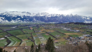
Abstract/Description
Due to climate change, long periods of heat without rain are becoming more frequent in the sandstone climbing areas of Bohemian and Saxon Switzerland. In the environment of these sandstone rocks, which is prone to greater dryness, the risk of forest fires is significantly increasing, the monitoring and management of which is made worse by poor terrain accessibility. The situation is also worsened by the extensive bark beetle disaster, which is also partly caused by the long-lasting heat and drought. Recently, therefore, in the summer period, there has been an increasing number of closures of entrances to forest stands around the rocks, both on the Czech and Saxon sides, and other restrictions affecting climbing activities and tourism in the unique terrains of sandstone rock towns. The culmination of the worsening situation (although not the only cause) was a huge forest fire in the Bohemian-Saxon Switzerland National Park in July 2022, which affected more than 1060 hectares of the national park. The fire took 20 days to extinguish and at its peak was extinguished by nine helicopters, five aircraft and a total of about 700 people. In addition to the damage to the forest, the high heat also caused irreversible damage to rock towers and walls. CCF is a partner of the Agency for Nature and Landscape Conservation and cooperates very closely with the Administration of the Bohemian Switzerland National Park, where it is a member of the Council. Thanks to this cooperation, the CMA actively helped to repair the damage caused by the fire, and this cooperation in the form of monitoring the affected areas is still ongoing. However, our cooperation with the national park does not concern only this one event, but has a long-term and systematic character. Our presentation describing the largest forest fire in the history of the Czech Republic and our cooperation with the national park, negotiating exceptions allowing climbing activities, mapping problematic areas requiring closures, building access routes, and informing the public and climbers about protective measures and entry restrictions through our database and map application.